Triangle Inn Information
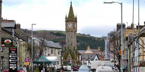
The Triangle Inn is located in Cwmdauddwr which, although a small village at first sight, is in fact very deceptive. It has two mentions in the Guinness Book of Records. It is the largest Parish in Great Britain. The name Cwmdauddwr means “the valley of the Two Waters” in Welsh; these being the Rivers Wye and Elan.
Rhayader and Cwmdauddwr form the gateway to the Elan Valley “The Lakeland of Wales”. The area offers some of the most beautiful countryside and breathtaking scenery in Wales.
On this page there are some details of places to go & things to do - some within walking distance, others within a 50 mile radius. There are a variety of links on this page (all of which open in a new window) with further information. There are so many great places nearby that we couldn't possibly list them all but hope this whets your appetite!
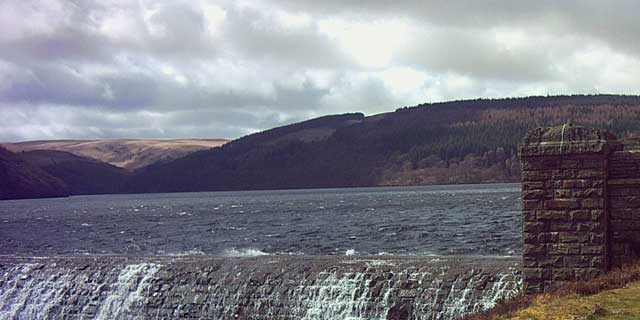
The Elan Valley is a river valley situated to the west of Cwmdauddwr and covers 70 square miles (180 km2) of lake and countryside.
The valley contains the Elan Valley Reservoirs and Elan Village, designed by architect Herbert Tudor Buckland as part of the same scheme. The Elan Village is the only purpose-built Arts and Crafts "Model Village" in Wales.
It is also famous for its picturesque scenery. Over 80% of the valley is designated as Sites of Special Scientific Interest where the wildlife is monitored.
Walking
Elan Valley Trail
There is open access over most of the 70 square mile Valley, and there are over 80 miles of designated rights of way. There are many leafletted walks and trails with a good mixture of lengths to cater for all, including nature trails and scenic walks. Leaflets are available from the Elan Valley Visitor Centre.
The Elan Valley Trail is a surfaced path which follows the route of the old Elan Valley Railway and is suitable for use by walkers, horse riders, cyclists, pushchairs and wheelchairs. Cycle hire is available from the Cycle Shop in Rhayader. The start of the Trail is approximately 100 yards from the Triangle Inn.
Rhayader to Rhyd-y-benwch (Plynlimon)
Distance: 24¼ miles (38.8km). High Point: 477m (1,575ft) Nantyhendy Hill.
Click here for a map. From the Triangle inn, cross the bridge and turn first left. This is the most exposed and mountainous section of the Wye Valley Walk. It starts in small fields and woods but rises quickly into rugged hills with mountains rising ahead. There are drops to the rocky banks of the river and short stretches along narrow lanes and railway embankments, but the inevitable climb begins after about 10 miles at the Dernol Valley, drops to Llangurig, then climbs again up the slopes of Plynlimon.
Rhayader to Builth Wells
Distance: 16½ miles (26.4km). High Point: Graig Allt-y-bont 380m (1,246ft). Click here for a map. From the Triangle Inn cross the bridge and turn right into the Water Lane. Just below the rapids, used by canoeists, there is a four mile walk over undulating moorland and views over Rhayader. There is little in the way of towns and villages in the early part of the walk. The latter part of the walk is through plantations, small woods, fields and tree-lined avenues to Builth Wells.
Wye Valley Walk
The 136-mile Wye Valley Walk, way-marked by the distinctive “leaping salmon” logo, starts at Chepstow in Monmouthshire and ends at its source at Plynlimon, in Powys in mid-Wales.
Local places of interest
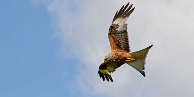
Red Kite Feeding Station at Gigrin Farm, Rhayader
Wild Red Kites are fed at Gigrin Farm every day of the year, at 2 pm during the winter months, and at 3 pm during the summer. Watch from the bird hides as with breathtaking feats of aerial piracy red kites compete with buzzards and crows for choice pickings. As the first crows land amongst the meat the kites go on the offensive. They watch and wait their chance to furl their wings, dive in , skimming the ground to snatch a scrap before rising to escape the beaks of angry crows.
Gilfach Nature Reserve at St Harmon, Rhayader
Gilfach Nature Reserve, run by The Radnorshire Wildlife Trust is a fantastic site for bird watching (including Red Kite, Dipper and Pied Flycatcher) and walking (on a well laid-out network of sign-posted and way marked trails). Situated in a beautiful setting at the confluence of the Marteg River with the River Wye in the Cambrian Mountains of Mid Wales, Gilfach is locally unique because of its wide variety of habitats: high moorland to enclosed meadow; oak woodland to rocky upland river. Because of this variety the farm supports a tremendous abundance of birds and animals within a comparatively small area. This richness of wildlife has adapted to living in the various habitats created over the centuries through the practice of traditional farming.
There is a gift shop and restaurant area, in addition to other picnic sites accessible to wheelchairs.
Rhayader Museum & Gallery, Rhayader
Rhayader Museum and Gallery has been described as a little gem. There is a strong focus on the history of the local area, including the Cambrian Mountains and the Elan Valley. The exhibitions show how landscape and people have shaped the community as it is now. Inside you will find interactive displays, plenty of stories to listen to about the area from local people and films to watch, along with displays of objects.
There is a strong focus on the arts which means that the interpretation for exhibitions can be very different to what you might expect from a local museum. It is only by visiting that you will be able to see that it lives up to its reputation. Local artists and craft people supply the shop with original and sometimes unusual gifts. There is also an interesting selection of books for a holiday read or to take home as a memento.
Llandrindod Wells
Located 11 miles South-East of Cwmdauddwr, Llandrindod Wells (alternative link HERE), on the River Ithon, developed as a spa town in the 19th century.
The architecture of the town includes many buildings in ornate styles dating from the boom period of the Victorian and Edwardian eras including the Metropole and the Glen Usk hotels, the Albert Hall theatre and former county hall building adjacent to it.
There are also buildings in the Art Deco style including two striking former garages, Pritchard's and the Automobile Palace. The latter was notable for a collection of antique bicycles owned by the proprietor, Tom Norton, which were displayed suspended from ceilings in the building. The building has in recent years been renovated and is now home to several small businesses and the National Cycle Museum, featuring some of the bicycles originally displayed in the garage.
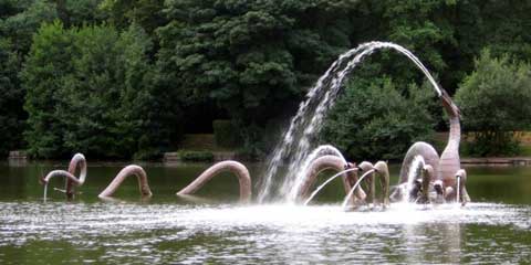
Above the town there is a large man-made lake popular for fishing and, in recent years, model boating. In the centre of the lake is a striking sculpture of a water serpent and leaping carp, the scales of which are made of thousands of copper plates initialled by local people and visitors during construction of the work during 2005. Beside the lake a distinctive tree-trunk sculpture known as the Llandoddy has been carved "to create a corporate image ... to attract tourists and provide the town with a strong identity for people to rally round."
An 18-hole golf course, established in 1905, features challenging topology and sweeping views over the lake, the town and surrounding countryside. The town has international standard outdoor bowling greens dating from 1912 which hosts national and international events and a newer indoor bowling centre. Llandrindod Wells also hosts the recently-established Heart of Wales Walking Festival.
The town's railway station is the closest to Rhayader & Cwmdauddwr. Please click HERE for National Rail's Llandrindod page.
Slightly further afield
Devil's Bridge
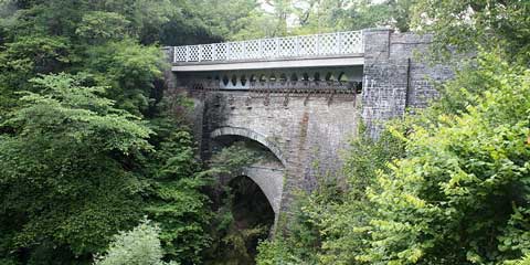
Devil's Bridge in Ceredigion is about 20 miles from Cwmdauddwr. Its main feature is the bridge of the same name which spans the Mynach, a tributary of the Rheidol. It consists of three bridges built above each other. The most recently built was an iron bridge in 1901 which was built over a stone bridge constructed in 1753 when the original bridge was thought to be unstable, using the original bridge built (1075 - 1200) to support the scaffolding.
The bridge is at a built where the Mynach falls around 90 metres (300 ft) and meets the Rheidol.
Legend says that the bridge was built by the Devil as it was too difficult for mortal people to build. The Devil built the bridge in return for the soul of the first life to cross the bridge, but the Devil was tricked by an old woman who threw bread onto the bridge and her dog followed, thus becoming the first life to cross the new bridge.
The bridge is a major tourist attraction; turnstiles control access (in 2008, at £1 a person) to a view of the bridges. Over the other side of the road, £3.50 grants a longer walk to view the Mynach Falls. This longer walk also includes the precipitous stone steps known as Jacob's Ladder named after the Biblical description of a ladder to the heavens.
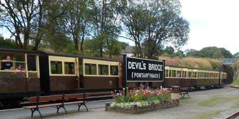
Devil's Bridge is served by Devil's Bridge railway station on the Vale of Rheidol Railway, which opened between Aberystwyth and Devil's Bridge in 1902 (note - if between trains, there isn't really time to take the longer walk) – see below.
Devil's Bridge Railway Station
The station serves the eastern terminus of the preserved Vale of Rheidol Railway. The line is a narrow-gauge 1 ft 11¾ in (603 mm) gauge heritage railway that runs for 11¾ miles between Aberystwyth and Devil's Bridge in Wales, UK. It was the last line to be operated by steam as part of the nationalised British Railways network, until it was privatised in 1989.
Trains run every day during the summer months and on certain other days during the rest of the year. Check the published timetable to avoid disappointment.
The station has two principle platforms, each with a hard tarmac surface. Platforms on this railway are low-level, as passenger coaches are designed for ground level access, due to the number of intermediate stations without platform surfaces. The two platform lines both terminate in buffer stops, and each has a headshunt forward of bi-directional cross-over points for locomotive release. In practice it is unusual to see more than one platform in use under the current timetable.
The station is equipped with a water tower, and station buildings providing waiting room, booking hall, booking office, and staff room, as well as lavatories. A separate temporary structure in the car park currently serves as a refreshment room and souvenir shop on railway operating days.
Aberystwyth
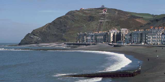
Aberystwyth is a historic market town, administrative centre and holiday resort in Ceredigion approximately 30 miles scenic drive from Cwmdauddwr across the beautiful Cambrian Mountains. It is locally known as Aber, and is located at the confluence of the Rivers Ystwyth and Rheidol.
Since the late 19th Century it has also been a major Welsh educational centre, with the establishment of the first University in Wales in 1872. The permanent population is around 12,000, but for nine months of the year the 7,000 resident students associated with Aberystwyth University take this total to about 19,500 people.
Aberystwyth is a major tourist centre and a cultural link between North Wales and South Wales. Constitution Hill is scaled by the Aberystwyth Electric Cliff Railway giving access to fine views and other attractions at the top, while much of the finest scenery in Mid Wales lies within easy reach of the town. This includes the wilderness of the Cambrian Mountains, whose valleys contain forests and meadows which have changed little in centuries. A convenient way of reaching the interior is by the preserved narrow gauge Vale of Rheidol Railway.
Although relatively modern, the town contains a number of historic buildings, including the remains of the castle and the Old College of Aberystwyth University nearby. The Old College was originally intended to be a hotel, but due to a lack of funds the shell of the building was sold to the university. The new university campus overlooks Aberystwyth from Penglais Hill to the east of the town centre. The terminus for the standard gauge railway is also very impressive being built in 1924 in typical style of the period.
The architecture is a mix of Gothic, Classical Revival and Victorian, and the town is sometimes referred to as "the Oxbridge of Wales".
The town is generally regarded as the capital of Mid Wales, and several institutions have regional or national offices there. Perhaps the most important of the public bodies located in Aberystwyth is the National Library of Wales. The library also incorporates the National Screen and Sound Archive of Wales, one of six British regional film archives. The Royal Commission on the Ancient and Historical Monuments of Wales, which maintains and curates the National Monuments Record of Wales (NMRW), provides the public with information about the built heritage of Wales.
Borth, Clarach & Ynyslas
The old fishing hamlet of Borth (about 35 miles from Cwmdauddwr) boasts one of Ceredigion's longest and most golden of beaches - stretching over two miles in length to Ynyslas where the Dyfi National Nature Reserve boasts an impressive sand dune system. Looking over the estuary from Ynyslas, the pretty harbour village of Aberdovey can be seen.
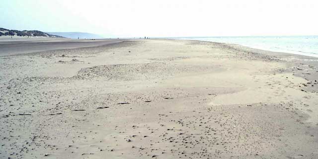
Borth's award-winning beach is of a particularly shallow gradient but many are fooled into thinking the steep pebble bank visible at high tide is representative of the ebb-tide scenario. Nothing could be further from the truth! Because of its shallow waters, Borth's beach is particularly popular with sailboard enthusiasts and families with younger children.
A Welsh legend tells of a long-ago era prior to an area of Wales - called Cantre'r Gwaelod - disappeared under the waters of Cardigan Bay. The legend has it that, just like parts of the Netherlands, Cantre'r Gwaelod was protected from being swamped by the ocean waters via a series of dykes and dams. One night, a feast was held at Cantre'r Gwaelod and Seithennyn, the man entrusted with the job of staying sober to staff the watchtower that night, let his compatriots down to the effect that the sea breached the defences and the land of Cantre'r Gwaelod was completely drowned.
Only a legend? Well, at particular times of year the lowest tides reveal - on Borth's beach - the stumps and trunks of old, old forests long hidden under the golden sands....
Besides listening to a wealth of local legends, there are plenty of things to see and do within Borth and in the surrounding area.
To its north and east Borth is surrounded by protected sites; a massive peat bog - Cors Goch Fochno - and the magnificent sand dune system of the Dyfi National Nature Reserve at Ynyslas. Here you will find a seasonal Information Centre operated by the Countryside Council for Wales where the significance of the nature reserve is explained in easy to follow detail.
Borth and Ynyslas represent the northern terminus of the Ceredigion Coast Path. From Borth, the Coast Path proceeds through Clarach towards Aberystwyth.
Borth is also the western terminus of one of Ceredigion's other linear paths climbing high into the Cambrian Mountains and linking to the Forestry Commission Wales Visitor and Red Kite Feeding Centre at Nant Yr Arian, Devil's Bridge, Cwm Ystwyth & it's mines, the historic Hafod Picturesque Landscape and Pontrhydygroes before proceeding to Pontrhydfendigaid with an option to visit the ruins of Strata Florida Abbey, once the Westminster of Wales. On completion of the Ystwyth Trail, at the end of June 2008, this route will be capable of forming a grand circle returning via the Ystwyth Trail towards Aberystwyth.
Aberdovey & Tywyn
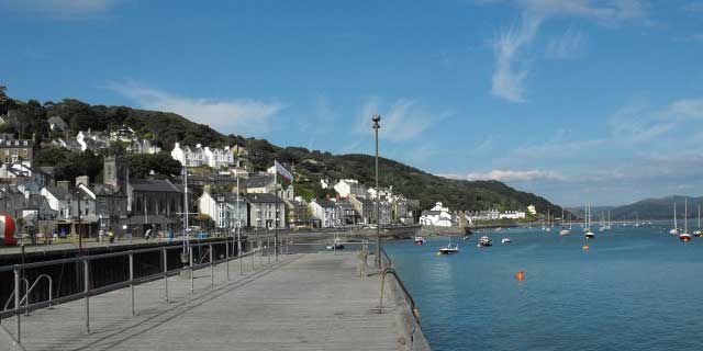
Over the other side of the estuary from Ynyslas, Aberdovey is approximately 42 miles from Cwmdauddwr. Although less than a mile from Ynyslas "as the crow flies" it's a 22 mile journey all the way up, and back down the estuary via Machynlleth. This small seaside village nestles on the north side of the Dyfi / Dovey estuary and is a popular destination for visitors from all over the world.
A thriving little harbour resort set within the Snowdonia National Park, where the river Dyfi meets the blue waters of Cardigan Bay. Aberdovey has watersports galore - sailing, sail & surf boarding, rowing, canoeing, fishing and boat trips. In the summer, there are yachting regattas and other water spectacles along with family entertainment on its award-winning beaches. Aberdovey boasts some of the finest beaches in Britain with four miles of golden sand-dune backed shoreline running north to Tywyn. The championship links golf course lies to the landward side of the dunes.
You don't need to travel too far from Aberdovey to find a different world - that of spectacular mountain and valley scenery. The peaks of the Cader Idris and Aran Fawddwy ranges are within easy reach and are complimented by the charm of the Dovey and Dysynni valleys nearby. An ideal area for walkers, climbers and wildlife watchers.
Just to the North of Aberdovey is Tywyn. The name derives from the Welsh tywyn ('beach, seashore, sand-dune') and the town is sometimes referred to as Tywyn Meirionnydd. The town is noted for its Norman parish church of St Cadfan housing St Cadfan's Stone dating from the eighth or ninth century and inscribed with the oldest known written Welsh. Extensive dunes are still to be found to the south towards Aberdyfi (Aberdovey), and in Tywyn itself the beach and the extensive promenade are key attractions. To the north lies the mouth of the Afon Dysynni, to the north-east the rich farmland of Bro Dysynni, and to the east the hills of Craig y Barcud and Craig Fach-Goch.
The Talyllyn Railway, a historic narrow-gauge steam railway, runs from Tywyn to Abergynolwyn and Nant Gwernol. The line passes the delightful Dolgoch Falls and there are excellent forest walks at Nant Gwernol.
Machynlleth
Approximately 32 miles North from The Triangle, Machynlleth is the ancient capital of Wales, site of Owain Glyndwr's 15th Century Welsh parliament. 'Mach' is a small market town with a population of around 2000. It sits in the lower Dyfi Valley about 10 miles in from the coast and is home to the Centre for Alternative Technology and King Arthur's Labyrinth.
There is a Glyndwr Festival in the first week in September. The Machynlleth Festival takes place in the auditorium in The Tabernacle late August every year. During the week eminent performers take part in events ranging from recitals for children to jazz.
Next to The Tabernacle you can find MOMA - The Museum of Modern Art. Throughout the year MOMA shows Modern Welsh Art, a constantly changing exhibition featuring leading artists from Wales. Individual artists are spotlighted in a series of temporary exhibitions.
Paintings and drawings from the Tabernacle Collection are shown in rotation. Works in this permanent collection include Portrait of William McElroy by Augustus John, Toasting by Stanley Spencer and Portrait of a Woman by Percy Wyndham Lewis. MOMA Wales owns Waterfall, Ogwen, Cottages, Cilgwyn, Carreg Cennen and Road above Deiniolen by Sir Kyffin Williams. The Brotherhood of Ruralists is represented by Graham Arnold's Last Poems (A E Housman) and Journal 1997 and by Ann Arnold's Clare's Countryside (8) and The River Dyfi. There are also two drawings of Dylan Thomas by his friend Mervyn Levy.
The main street boasts attractive shops and galleries to browse around and find that unique gift to take home. You will find sellers of arts and crafts, demonstrations of renewable energy sources, beautiful scenery, and Welsh history, all in one small Welsh town.
Llanwrtyd Wells
Only 20 miles South of Cwmdauddwr, the small town of Llanwrtyd Wells in the parish of Llanwrtyd, Powys, is situated on the River Irfon. With a population of 601 people (United Kingdom Census 2001), it claims to be the smallest town in Britain, although Fordwich in Kent has a smaller population.
Llanwrtyd Wells began its life as a tiny hamlet called Pont-Rhyd-y-Fferau (Bridge over the Ankle Deep Ford). Llanwrtyd, or as it is known today, Old Llanwrtyd is centred around the church of St David’s further up the valley towards Abergwesyn. It was the discovery of the mineral waters in 1732 that originally brought fame to Llanwrtyd and it grew as a spa town, based around the Ffynon Droellwyd spring, (or Stinking Well because of the smell of hydrogen sulphide gas that was given off when you breathed the vapours) which still exists. The town was also known as an eisteddfod site. Today it is better know for eccentric sports such as The World Bog Snorkelling Championships, The Man versus Horse Marathon and The Real Ale Wobble!
The World Bog Snorkelling Championship, first held in 1985, takes place annually every August Bank Holiday at the dense Waen Rhydd peat bog. Other bog snorkelling events take place, particularly in Wales, including the associated mountain bike bog snorkelling (where competitors must ride through the bog on specially prepared mountain bikes), and the Bog Snorkelling Triathlon.
The town is the home of The Heart of Wales Brewery. One resident Robin Kevan who is also known as "Rob the Rubbish" has become famous for cleaning up Britain's countryside.
Please help us keep this page up-to-date by reporting any broken links to our Webmaster.